Ancient Life
Babylocentricity: An ancient map of the universe
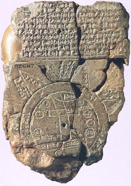

It’s just a badly damaged, 4-inch-high clay map inscribed on both sides with cuneiform text. But it gives us a clean bird’s-eye view of the ancient Babylonians themselves.
The Babylonian Map of the World shows a vast circular continent completely surrounded by a great ocean (labeled marratu, meaning “salt sea”). Beyond the ocean are eight uncharted regions, depicted as triangles.
Prominently at the center of the world is Babylon,which is represented as a large rectangle. The map also shows Assyria, as a much smaller circle, and several cities, such as Susa. The Euphrates River, depicted as a pair of parallel lines, flows from the northern mountains to Babylon, where it bisects the city, turns due south and empties into a marshland (labeled apparu, or “swamp”). This marshland is the region where the Euphrates River merges with the Tigris River (not shown on the map) before draining into the Persian Gulf.
No one knows where the map was found, though many scholars believe it came from Sippar or Borsippa, both about 50 miles north of Babylon. The map’s date is also unknown. It cannot be older than the ninth century B.C. because it uses certain words—such as the word for salt sea, marratu—that did not appear in cuneiform texts until the reign of the Assyrian king Shalmaneser III (858–824 B.C.).
Already a library member? Log in here.
Institution user? Log in with your IP address.