The Ancient Cardo Is Discovered in Jerusalem
1976 excavations in Jerusalem have revealed a portion of the ancient Cardo—the principal street through the city depicted on the mid-6th century A.D. Madaba map (see illustrations). This famous mosaic map of the Holy Land, which contains the earliest known representation of Jerusalem, shows the city in crowded, stylized detail as it appeared at the time—a walled city viewed from above and looking to the east. It is filled with churches and monasteries; across the city passes a broad colonnaded road connecting the northern gate with the southern side of the city. Portions of this road, the Cardo, have been uncovered by Professor Nachman Avigad of the Hebrew University along the present Street of the Jews near the boundary between the Jewish and Armenian Quarters of the Old City.
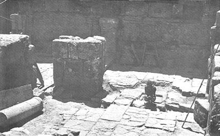
About 300 square meters of the Cardo have now been exposed in several different locations. The excavations have revealed the major features of the 60-foot wide street—a central open roadway flanked on either side by a covered columned portico. Many columns have been found near the road, re-used in various ways as part of later structures. Several elaborately carved capitals were also found in the vicinity of the street.
At one location parallel to the road a 15-foot high ashlar wall appeared, containing holes in which once rested the beams which spanned the portico; the wall was the back of the portico structure. Drainage channels covered by stone slabs run along the roadway between the porticoes and the central roadway.
Already a library member? Log in here.
Institution user? Log in with your IP address.