Without Avigad's Pictures—Is the Jerusalem Cardo Roman After All?

One of the most sensational finds of recent excavations in Jerusalem was Professor Nachman Avigad’s discovery of the ancient Cardo, the main north-south thoroughfare through the city.
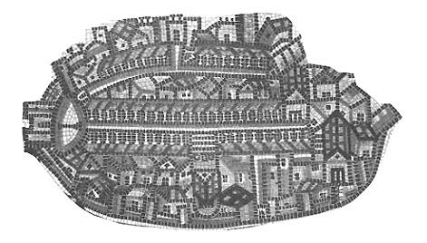
The Jerusalem Cardo was well-known long before its discovery in an excavation. It is clearly pictured on the famous Madaba map, a mosaic map of the world found in 1884 in the ruins of a Byzantine church in Madaba, now in Jordan. The center jewel of the map is the city of Jerusalem (see illustration). And the central street of the city is the Cardo—portrayed as a wide thoroughfare with a many-columned portico on either side.
Although the Madaba map dates from the late Byzantine period (mid-16th century A.D.), scholars long assumed that the Cardo as pictured on the Madaba map was actually constructed by the Roman Emperor Hadrian at about the time of the Second Jewish Revolt (the Bar-Kochba revolt—132–135 A.D.) which he crushed. Jews were then forbidden to live in Jerusalem and the city was rebuilt as a Roman city named Aelia Capitolina.
At that time, it was thought, the Romans laid out the city like a standard Roman camp, with two major intersecting thoroughfares dividing the city roughly into four quadrants—the Cardo running from north to south and the Decumannus running from west to east.
Already a library member? Log in here.
Institution user? Log in with your IP address.