Understanding the Madaba Map
Sidebar to: Putting the Bible on the Map
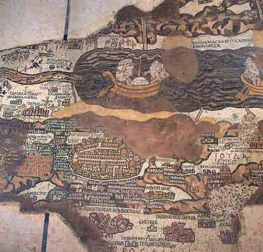
Cities, villages and topographical features of the Holy Land—many confirmed by recent archaeological discoveries—appear on this portion of the famous Madaba mosaic map. Discovered in 1884 on the floor of a sixth-century A.D. church in Madaba, Jordan (20 miles southwest of Amman), the fragment in the photograph is about half the extant portion of the map.
Details Outside Jerusalem
The Madaba map is a blend of whimsy, impressionistic rendering and precise attention to detail. Because the map is oriented with east at the top, the Jordan River flows horizontally from left to right into the Dead Sea. In the sea, two boats bearing sailors (only some hands and feet remain from the original mosaic) float high on the turbulent water. Several fish are swimming in the Jordan River. A fish at the southern end of the river seems to swim deliberately away from the sea after having tasted the heavy salt content in the water. Above the Dead Sea, the steep mountains of Moab are depicted in pink and yellow on their lower arid slopes and gray-green on their more fertile upper reaches.
Already a library member? Log in here.
Institution user? Log in with your IP address.